Prelude
Cyclone Zelia Threat Looms Over Western Australia
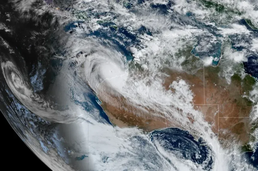
Cyclone Zelia has now become a Category 5 storm, which is the strongest type of cyclone. With wind speeds over 252 km/h, heavy rainfall, and huge ocean waves, it is a serious threat to Western Australia, especially the towns of Port Hedland, Karratha, and Dampier.
Authorities have issued severe weather warnings and evacuation alerts for areas most at risk. Residents are advised to stay indoors, secure their homes, and follow emergency guidelines.
In this article, we’ll explain how Cyclone Zelia could impact these regions, what safety steps you should take, and how to prepare for extreme weather conditions to protect yourself and your loved ones.
What is a Category 5 Cyclone?
A Category 5 cyclone is the most extreme classification on the Saffir-Simpson Hurricane Wind Scale, indicating devastating potential damage.
Category 5 Cyclone Characteristics:
- Wind speeds exceeding 252 km/h (157 mph) – Enough to cause catastrophic damage to buildings and power lines.
- Storm surges of 6+ meters – Coastal areas risk major flooding and destruction.
- Extreme rainfall – Increased risk of flash floods and landslides.
- Severe infrastructure damage – Homes, roads, and power grids can be severely affected.
Previous Category 5 Cyclones in Australia
- Cyclone Tracy (1974) – Destroyed 80% of Darwin.
- Cyclone Yasi (2011) – Caused $3.5 billion in damages across Queensland.
- Cyclone Debbie (2017) – Resulted in widespread flooding.
Cyclone Zelia could join the list of Australia’s most destructive storms if it makes landfall at full strength.
Cyclone Zelia’s Current Location & Projected Path
- Current Position: 145 km north-northwest of Port Hedland, WA
- Projected Landfall: Between Dampier and Grey
- Potentially Affected Areas: Karratha, Port Hedland, Dampier, and surrounding regions
Meteorologists predict Cyclone Zelia will intensify further before landfall. The Australian Bureau of Meteorology (BoM) urges residents to stay alert and follow official warnings.
Check live updates from BoM here
Potential Impact on Western Australia
Destructive Winds
- Expected wind speeds: Over 280 km/h in some areas
- High risk of roof damage, power outages, and flying debris
Storm Surges & Flooding
- Coastal areas could see flooding up to 6 meters above sea level.
- Residents in low-lying areas should evacuate immediately.
Power & Communication Disruptions
- Strong winds may knock down power lines, leading to blackouts.
- Mobile networks & internet services could be impacted.
Essential Safety Measures & Preparation Tips
Home Preparation
- Reinforce doors, windows, and roofs.
- Move outdoor furniture indoors.
- Check emergency exits and safe zones.
Emergency Kit Essentials
- Water supply (at least 3 days’ worth)
- Non-perishable food
- Flashlights & batteries
- First-aid kit & necessary medications
- Important documents (stored in waterproof bags)
Evacuation Planning
- Follow evacuation orders from local authorities.
- Ensure your vehicle has enough fuel.
- Identify evacuation centers in advance.
What to Do After the Cyclone Passes
- Avoid floodwaters – They can be contaminated or hide dangers.
- Inspect your home for damage before re-entering.
- Stay away from downed power lines and report hazards.
- Contact emergency services if assistance is needed.
Read more safety guidelines from the Australian Government here
TN HEADLINES24 INSIGHTS
Cyclone Zelia has intensified into a Category 5 storm, the most powerful classification for tropical cyclones. With wind speeds exceeding 252 km/h, it poses a severe threat to Western Australia’s northwest coast. The storm is currently 145 km north-northwest of Port Hedland and is expected to make landfall between Dampier and Grey, impacting towns like Karratha and Port Hedland. Residents should prepare for destructive winds, heavy rainfall, and dangerous storm surges.
Authorities are urging people to follow safety guidelines, secure properties, and stay updated. Cyclones of this intensity can cause widespread damage to homes, infrastructure, and power lines. Emergency teams are on high alert, and evacuations may be necessary in high-risk areas. Stay informed, stay safe, and follow official updates from the Bureau of Meteorology (BoM) and TN HEADLINES24.
For more insights on other trending news, click here!
FAQs
1. What is a Category 5 cyclone?
A Category 5 cyclone is the highest classification, with wind speeds exceeding 252 km/h and severe destruction potential.
2. When will Cyclone Zelia make landfall?
Current predictions suggest landfall between Dampier and Grey within the next 24-48 hours.
3. Which areas are most at risk?
Port Hedland, Karratha, and Dampier are in Cyclone Zelia’s direct path and face the highest risks.
4. What should I do if I live in a flood-prone area?
Evacuate immediately if instructed. Move to higher ground and avoid flooded roads.
5. How can I prepare for Cyclone Zelia?
Stock up on food, water, batteries, and medical supplies, and follow evacuation orders if issued.
*Visit Bureau of Meteorology (BoM) for real-time updates.
TN HEADLINES24 READERS’ INSIGHTS
- What are your thoughts on Cyclone Zelia’s impact?
- Have you or someone you know been affected by previous cyclones?
- How prepared do you feel for extreme weather events?
Share your insights in the comments below! Your experiences help others stay informed and prepared.
TN HEADLINES24 BOTTOM LINE
Prepare, Stay Informed & Stay Safe
Cyclone Zelia is a Category 5 powerhouse, and its impact on Western Australia could be severe. Don’t wait until it’s too late—prepare now.
- Follow evacuation orders
- Stock up on emergency supplies
- Stay updated with reliable news sources
Share this article to help others prepare.
TN HEADLINES|TEST YOURSELF
1. What is the highest classification for cyclones?
A) Category 3
B) Category 4
C) Category 5
D) Category 2
2. How fast are Cyclone Zelia’s wind speeds?
A) 180 km/h
B) 220 km/h
C) 252 km/h+
D) 150 km/h
3. What areas are most at risk from Cyclone Zelia?
A) Sydney and Melbourne
B) Port Hedland and Karratha
C) Perth and Adelaide
D) Canberra and Brisbane
4. What is the biggest danger from storm surges?
A) Wind damage
B) Lightning strikes
C) Coastal flooding
D) Landslides
5. Which past cyclone devastated Darwin in 1974?
A) Cyclone Yasi
B) Cyclone Debbie
C) Cyclone Tracy
D) Cyclone Damien
6. Where should you store important documents during a cyclone?
A) On the table
B) In a waterproof bag
C) Under the bed
D) In the fridge
7. What is a key preparation tip before a cyclone?
A) Leave windows open
B) Secure outdoor furniture
C) Ignore evacuation warnings
D) Avoid checking the weather
8. What government agency provides cyclone updates in Australia?
A) NASA
B) Bureau of Meteorology (BoM)
C) WHO
D) FEMA
9. How high can storm surges reach in a Category 5 cyclone?
A) 1-2 meters
B) 3-4 meters
C) 6+ meters
D) 10+ meters
10. What should you do after the cyclone passes?
A) Stay in floodwaters
B) Inspect home for damage
C) Touch downed power lines
D) Ignore safety warnings
TN HEADLINES24|VOCABULARY CHALLENGE
1. What does “evacuation” mean?
A) Leaving a dangerous area
B) Building a new home
C) Ignoring warnings
D) Staying put
2. What is the meaning of “landfall”?
A) A new type of cyclone
B) The moment a cyclone hits land
C) Heavy rainfall
D) A government warning
3. Define “storm surge”:
A) A rise in sea level during a cyclone
B) A type of wind
C) A power outage
D) A lightning strike
4. What does “reinforce” mean?
A) Strengthen something
B) Remove something
C) Weaken a structure
D) Ignore a problem
5. What is “torrential rain”?
A) Light drizzle
B) Heavy downpour
C) Misty fog
D) No rainfall
6. What does “infrastructure” refer to?
A) Trees and mountains
B) Buildings, roads, and power lines
C) Weather reports
D) Cooking utensils
7. What does “forecast” mean?
A) Predicting the weather
B) Changing the temperature
C) Stopping the wind
D) Creating a storm
8. What is the meaning of “debris”?
A) Clean air
B) Broken pieces of objects
C) A type of tree
D) Ocean waves
9. Define “blackout”:
A) Loss of power
B) A type of cyclone
C) A storm warning
D) A fire emergency
10. What does “meteorologist” mean?
A) A storm chaser
B) A person who studies weather
C) A scientist who studies space
D) A cyclone survivor
ANSWER
TN HEADLINES24 QUIZ | TEST YOURSELF
1.C | 2.C | 3.B | 4.C | 5.C | 6.B | 7.B | 8.B | 9.C | 10.B
TN HEADLINES24 | VOCABULARY CHALLENGE
1.A | 2.B | 3.A | 4.A | 5.B | 6.B | 7.A | 8.B | 9.A | 10.B
Disclaimer: The information in this article is for general awareness and should not replace official government alerts and advisories. TN HEADLINES24 strives for accuracy, but details may change as Cyclone Zelia develops. Readers should verify updates from trusted sources like the Bureau of Meteorology (BoM). TN HEADLINES24 is not responsible for any decisions based on this content. Always follow safety guidelines and emergency authorities.